
Just after dawn in Imlil, the village is still half asleep. You hear mules on the stones, smell wood smoke from simple kitchens, and see guides checking headlamps and boots under a pale orange sky. This is how a mount toubkal guided trek really begins: quietly, with small practical details, not heroic drama.
Mount Toubkal rises to about 4,167 m, the highest peak in Morocco, the Atlas range and North Africa. A guided ascent turns this altitude and terrain into something structured and manageable, especially if you’re new to multi-day trekking in the High Atlas.
Micro-summary: A mount toubkal guided trek is a structured, supported way to reach the highest peak in North Africa, starting from the small mountain hub of Imlil and climbing into genuine high-altitude terrain.
Explore Toubkal Mount 4167m (3 Days)

What Is a Mount Toubkal Guided Trek
A mount toubkal guided trek is a short high-altitude journey in Morocco’s High Atlas, usually spread over 2–3 days, starting from Imlil (around 1,700–1,800 m) and climbing via the valley of Sidi Chamharouch to the Toubkal refuges and finally the summit at 4,167 m.
In practice, most guided treks include:
-
A road transfer from Marrakech to Imlil
-
A gradual hike to the refuge area (around 3,200 m)
-
An early-morning summit push and descent
-
Simple but hearty meals and shared accommodation in mountain huts
Guides are usually local professionals from nearby Berber villages, often working with muleteers and cooks who handle bags, food and logistics.

Micro-summary: Think of a mount toubkal guided trek as a compact 2–3 day high-altitude program with a local guide, refuge overnights and a clear structure from Marrakech to summit and back.
Why Choose a Guided Trek? (Safety, Logistics, Local Knowledge)
On paper, Toubkal is a non-technical hike in summer; on the ground, it’s a serious Atlas Mountains trek with fast altitude gain, unstable scree and weather that can turn quickly.
Key reasons to go guided:
-
Safety decisions
Local guides know how the snow sits on the summit cone, how fast temperatures drop at the col, and when strong winds make a turnaround smarter than pushing on. -
Logistics handled for you
They coordinate transport to Imlil, refuge bookings, food, water refills and timing on the trail, so you’re not troubleshooting in a second language with tired legs at 3,200 m -
Altitude and pacing
Experienced guides moderate the pace between Imlil, Chamharouch and the refuge, which aligns well with general high-altitude advice to avoid rapid, large jumps in sleeping. altitude. -
Current safety context
Official travel advisories for Morocco recommend using professional, recognised guides in mountainous or remote areas, and avoiding hiking completely alone. -
Micro-summary: A guide doesn’t just “show the way”; they handle logistics, judge conditions and manage pace in line with modern mountain and travel-safety advice.
Trail Overview (Terrain, Difficulty, Weather, Altitude)
Terrain
The trek starts among walnut trees and irrigation channels, turns into a stone mule track, then narrows into a mostly rocky valley. Higher up, the path crosses small boulder fields and sections of loose scree, especially between the refuge and the summit ridge.
Expect:
-
Solid but stony paths below the refuge
-
Loose gravel and scree on steeper upper slopes
-
Snow or ice from late autumn to early spring on shaded sections and the summit cone

Micro-summary: Most of the route is straightforward hiking terrain, but the upper slopes are loose and tiring; trekking poles make a real difference.
Difficulty
Most trekking operators describe Toubkal as “demanding but achievable” for fit hikers: big height gain, long summit day, no technical climbing.
-
Elevation gain from Imlil to summit is about 2,300–2,400 m.
-
Summit day often involves 6–9 hours of walking, including descent back to the refuge or all the way to Imlil.
-
Fitness matters more than speed; steady, consistent pacing wins.
Micro-summary: The challenge is endurance and altitude, not ropes and rock; trekkers who can hike several hours with a pack handle Toubkal better.
Weather
High Atlas weather is quick to change. Warm sun at midday can turn into sharp wind and low visibility higher up.
-
Best seasons: Spring (April–May) and autumn (September–October) usually offer the most stable mix of snow conditions and temperatures.
-
Summer: Hot, dusty approaches and strong UV at altitude.
-
Winter: Snow and ice common above the refuge, often requiring crampons and extra equipment under a qualified guide’s supervision.
Micro-summary: Pack for sun, cold and wind in the same day; even in good seasons, treat the upper mountain like a true alpine environment.
Altitude
The Toubkal altitude of over 4,000 m means almost everyone feels the thin air. Mild acute mountain sickness (AMS) can appear as you approach or sleep near the refuge and above.
Typical early symptoms:
-
Headache, reduced appetite
-
Unusual fatigue when climbing
-
Light nausea or restless sleep
Well-established altitude guidelines recommend gradual ascent, limiting jumps in sleeping altitude once above about 3,000 m and adding acclimatization days where possible.
Micro-summary: Altitude is the quiet factor that makes a mount toubkal guided trek serious; it’s manageable with careful pacing and honest listening to symptoms.
Typical Itinerary (Neutral Day-by-Day Outline)
Every company tweaks the schedule, but most mount toubkal guided trek plans follow a similar rhythm over 2–3 days.
Day 1 – Marrakech to Imlil, Hike to Refuge
-
Morning drive from Marrakech to Imlil, usually 1.5–2 hours.
-
Gear check with your guide, then gradual climb through terraces and small hamlets towards Sidi Chamharouch.
-
Breaks for tea and a simple lunch, then a steeper trail leads to the refuge area.
-
Evening spent resting, hydrating and watching the light disappear behind serrated ridges.
Day 2 – Summit Push and Descent
-
Pre-dawn start with headlamps, climbing on zigzags of scree and, in cold seasons, firm snow.
-
Steady ascent to the main ridge and onwards to the summit pyramid, typically reached in 3–4 hours.
-
Short summit stop for views over the High Atlas and surrounding ranges, weather permitting.
-
Long descent back to the refuge, then further down the valley to Imlil or another overnight stop, depending on the program.
Optional extra day
Some itineraries add a day before the summit to explore side valleys around Imlil or to break the ascent into shorter stages, which aligns well with conservative acclimatization advice.
Micro-summary: Most guided programs follow a simple pattern—approach to the refuge, early summit day, long descent—with the option of an extra day for comfort and acclimatization.
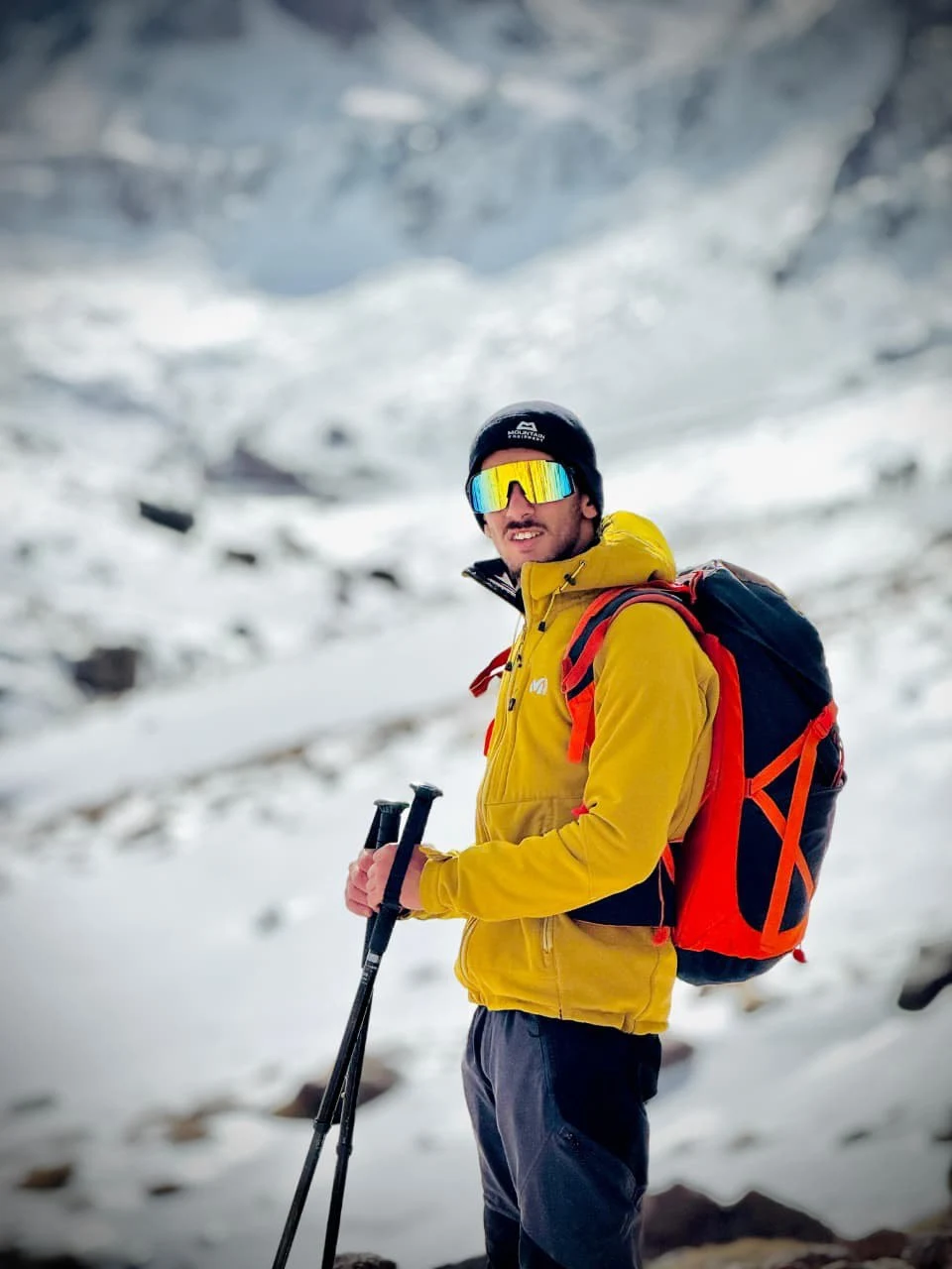
Gear and Packing Tips
Guides provide expertise, not your personal kit. Mountain and trekking resources for the Atlas consistently emphasize good footwear, layering and basic safety gear.
Core items
-
Sturdy, broken-in trekking boots with decent ankle support
-
Trekking poles for scree and long descents
-
30–40 L daypack with a comfortable hip belt
Clothing layers
-
Wicking base layer (top and bottom)
-
Warm mid-layer (fleece or light insulated jacket)
-
Waterproof, windproof shell
-
Warm hat, light gloves (thicker in winter)
Accessories
-
Sunglasses with strong UV protection and a brimmed cap
-
High-SPF sunscreen and lip balm
-
Headlamp with spare batteries for the early start
-
2–3 L of water capacity (bottles or hydration bladder)
Cold season extras
-
Gaiters, thick socks, more insulating layers
-
Crampons and sometimes an ice axe, usually arranged locally under guidance in true winter conditions
Micro-summary: Focus on solid boots, layered clothing, sun protection and one or two simple technical items—poles and a headlamp—rather than overpacking gimmicks.
Safety and Altitude Advice
Official mountain and travel health sources share the same core principles: go gradually, stay hydrated, react early to symptoms.
-
Hire registered, professional guides, especially in winter or if new to high altitude.
-
Stay on recognised paths instead of cutting across slopes.
-
Carry enough water, snacks and a small personal first-aid kit.
-
Avoid hiking alone in remote sections or late in the day.
Altitude guidelines (general, non-medical)
-
Consider an extra acclimatization day if you live at sea level and rarely trek above 2,500–3,000 m.
-
Watch for mild AMS signs: persistent headache, nausea, unusual fatigue, poor sleep.
-
If symptoms worsen with movement, descend; serious signs (confusion, breathlessness at rest) require immediate descent and medical help.
-
Many health authorities advise avoiding alcohol and heavy meals during the first days at altitude.
Micro-summary: The safest mount toubkal guided trek is conservative in timing and honest about symptoms—turning back can be the most experienced decision of all.
Cultural Notes (Local Villages, Etiquette)
Imlil and the surrounding valleys are Amazigh (Berber) communities that have turned farming tracks into trails for visitors heading to Toubkal
In the villages
-
Dress modestly around homes and mosques (covered shoulders and knees).
-
A simple “salam alaikum” or “tanmirt” (thank you in Tamazight) is always welcome.
-
Ask before photographing people, especially children.
In the refuge
-
Shared dorms mean earplugs are useful and quiet hours matter.
-
Boots stay in the designated area; use hut shoes inside.
-
Follow staff instructions for meal times, waste and water use—supplies are limited.
Micro-summary: Respect for village customs and simple hut etiquette turns a mount toubkal guided trek into a genuine cultural encounter, not just a peak bagging exercise.
FAQ – Mount Toubkal Guided Trek (Voice-Search Friendly)
Is Mount Toubkal suitable for beginners?
It can be, for fit beginners with some hiking experience who take a guided trek, respect the pace and understand that altitude above 4,000 m is demanding.
How many days do I need for a mount toubkal guided trek?
Most guided programs run over 2–3 days, with extra days used for acclimatization or exploring side valleys around Imlil.
What is the best time of year to climb Toubkal?
Spring and autumn usually offer the best combination of conditions; summer can be very hot, and winter brings snow and ice that require extra gear and skills.
Do I need special equipment?
In dry, snow-free conditions, standard trekking gear and good boots are usually enough; in winter, crampons and additional equipment are often necessary under a qualified guide.
Is trekking in the Atlas Mountains safe?
Travel advisories generally consider Morocco safe for trekkers who use professional guides, prepare properly and avoid isolated areas at night.
Key Takeaways / Summary

-
A mount toubkal guided trek offers a compact, high-altitude adventure on the highest peak in North Africa.
-
Guides bring essential safety, logistics and local knowledge that match current trekking and travel-safety recommendations.
-
Terrain is mostly hiking, with loose scree and possible snow near the summit, and real physical effort spread over 2–3 days.
-
Altitude management—slow ascent, hydration, early response to symptoms—is as important as physical fitness.
-
Respectful behaviour in Berber villages and mountain refuges deepens the experience beyond simply “reaching a summit.
Author Bio
Written by a trek journalist familiar with the High Atlas, combining field notes from the Toubkal valleys with recommendations from certified local guides and referencing public mountain-safety, climate and high-altitude health resources from Morocco and international organizations.
0 Comment